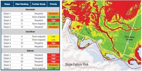
Slope Vulnerability Assessments
Identifying vulnerabilities and assessing risks to the transportation system.
In the Statewide Multimodal Transportation Plan, MnDOT committed to identifying vulnerabilities and assessing risks to the transportation system. In 2017, MnDOT started a slope vulnerability assessment project as part of an effort to better protect roads from flood damage.
The project focuses on a few key districts and involves creating maps that identify and categorize how likely slopes are to fail, negatively impacting state highways. The goal is to use data to identify known hazards and categorize areas of risk. By doing this, we are able to identify high-risk areas, prioritize future evaluation and develop plans to address the vulnerable slopes.
Learn more about work MnDOT is doing to protect roads from flood damage: www.mndot.gov/research/projects/slopes/slopes.html
