
Appendix A: Critical Urban and Rural Freight Corridors
Figure A-1: 2024 National Highway Freight Network in Minnesota
An interactive map is available at: https://experience.arcgis.com/experience/68fd0a0359ea4f9e9424de0ae9ab8b45
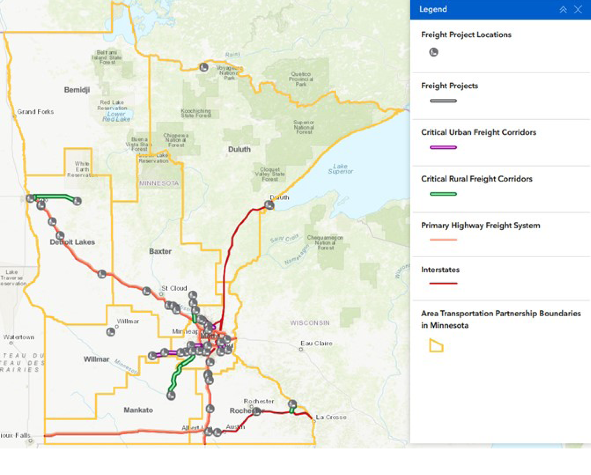
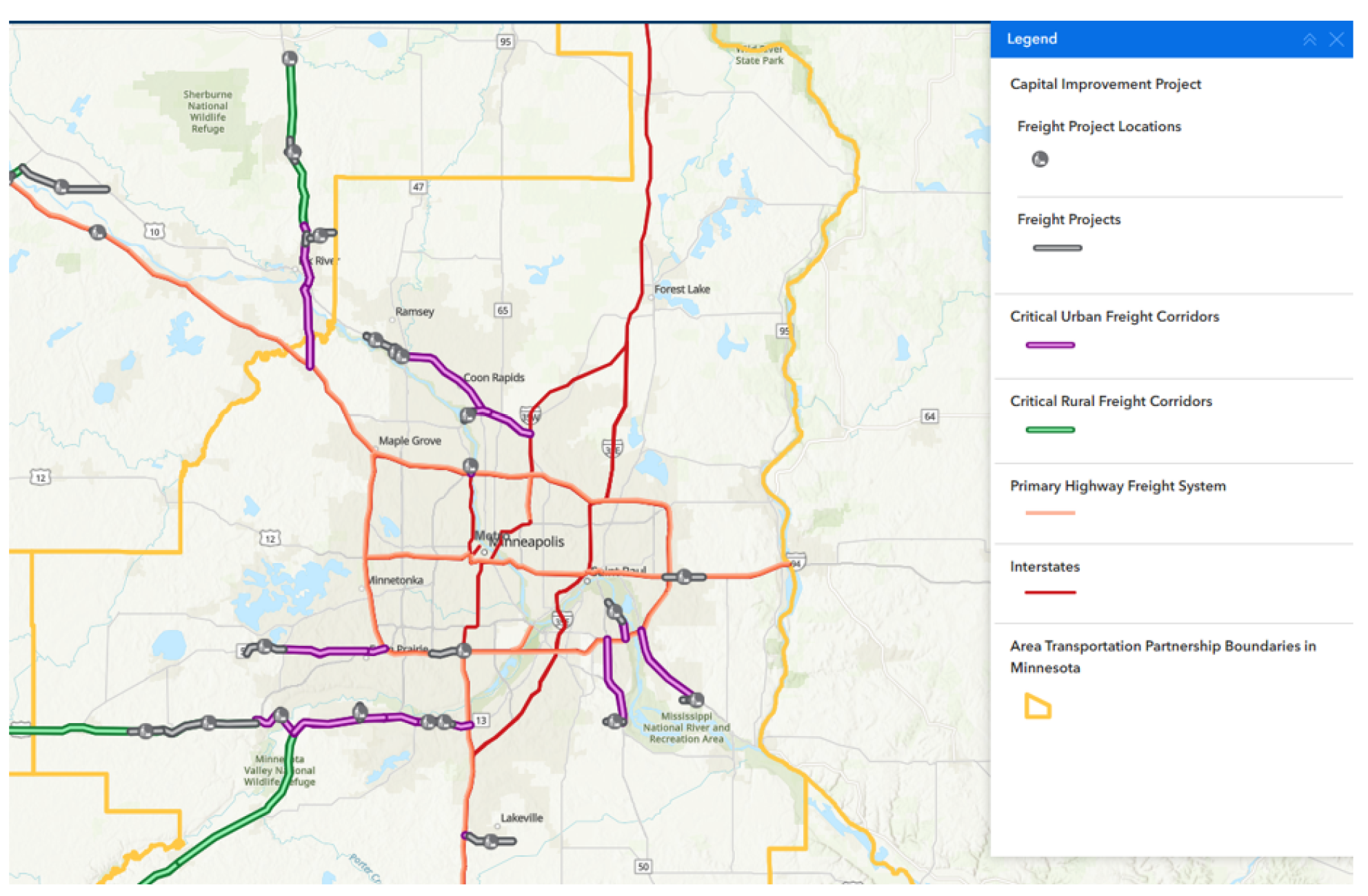
Figure A-2: 2024 CUFC/CRFC Corridor Designations, Twin Cities Metro Area
Critical Urban Freight Corridors
| Road Authority | Route | From | To | Length (miles) | CRFC ID |
|---|---|---|---|---|---|
| MnDOT Metro District | US 61 | CSAH 61 (Chaska Boulevard) | CSAH 11 (Jonathan Carver Parkway) | 2.48 | K |
| Carver County | CSAH 11 (Jon. Carver Pkwy) | CSAH 61 (Chaska Boulevard) | US 212 | 0.20 | K |
| MnDOT Metro District | MN 41 | US 61 | US 169 | 2.00 | K |
| MnDOT Metro District | US 169 | 130th Street NW in Shakopee | MN 13 Junction | 8.70 | J |
| MnDOT Metro District | MN 13 | US 169 | I-35 | 11.60 | J |
| Dakota County | CSAH 70 | I-35 | MN 3 | 4.00 | J |
| MnDOT Metro District | MN 252 | I-694 | 70th Avenue N | 0.90 | K |
| Scott County | CSAH 83 (Canterbury Road) | US 169 | 4th Avenue E | 1.05 | J |
| MnDOT Metro District | CSAH 56/MN 156 (Concord Avenue) | I-494 | Annapolis Street E | 3.45 | J |
| MnDOT Metro District | US 10 | I-35W | Armstrong Boulevard NW | 16.80 | K |
| MnDOT Metro District | US 52 | I-494 | 117th Street E in Inver Grove Heights | 7.50 | K |
| City of Inver Grove Heights | 117th Street E | CSAH 71 (Rich Valley Boulevard) | US 52 | 1.20 | J |
| Sherburne County | CSAH 33 | Auburn Street | CSAH 13/CR 34/Twin Lake Road NW | 1.70 | K |
| MnDOT Metro District | MN 101 | I-94 | US 169 | 6.90 | K |
| MnDOT Metro District | US 169 | MN 101 | 213th Avenue NW in Elk River | 4.70 | K |
| MnDOT Metro District | US 61 | I-494 | Innovation Road S/Keats Avenue | 7.49 | K |
| Washington County | CR 19A (Innovation Road S) | 100th Street S | US 61 | 0.12 | J |
| City of Cottage Grove | Miller Road/ 100th Street S | CR 19A (Innovation Road) | Jamaica Avenue S | 1.11 | J |
| MnDOT Metro District | MN 5 | I-494 in Eden Prairie | 80th Street in Victoria | 11.69 | J |
| MnDOT Metro District | US 610 | Mississippi River Bridge | 800 ft E of CSAH 1 (E. River Road) | 2.45 | K |
| - | - | - | Total Mileage | 96.04 | - |
Critical Rural Freight Corridors
| Road Authority | Route | From | To | Length (miles) | CRFC ID |
|---|---|---|---|---|---|
| MnDOT District 3 | US 169 | 213th Avenue NW near Elk River | CSAH 45/South Rum River Drive at US 169 in Princeton | 13.90 | F |
| Sherburne County | County Road 45 | CSAH 45/South Rum River Drive | 125th Street / 9th Avenue Circle | 0.20 | F |
| MnDOT District 4 | US 10 | MN 336 | Randolph Road in Detroit Lakes | 40.20 | C |
| City of Detroit Lakes | Kris Street | US 10 | Randolph Road | 0.10 | G |
| City of Detroit Lakes | Randolph Road | US 10 | Highland Drive | 1.10 | G |
| MnDOT District 6 | MN 43 | I-90 | W 4th Street in Winona | 8.17 | D |
| City of Winona | West 4th Street | MN 43 | Huff Street | 0.07 | D |
| City of Winona | Huff Street | W 4th Street | Riverview Drive | 0.10 | D |
| City of Winona | Riverview Drive | Huff Street | Theurer Boulevard | 2.25 | D |
| MnDOT District 3 | MN 24 | I-94 near Clearwater | CSAH 8 | 1.74 | F |
| Sherburne County | CSAH 8 | MN 24 | MN 25 / US 10 | 7.20 | G |
| MnDOT Metro District/District 8 | US 212 | Jonathan Carver Parkway / County Road 11 | MN 15 | 37.6 | F |
| Carver County | Jonathan Carver Parkway / County Road 11 | County Road 61 | US 212 | 0.20 | F |
| MnDOT District 8 | US 212 | 0.25 miles west of Morningside Drive | 0.25 miles east of Morningside Drive | 0.50 | G |
| City of Glencoe | Morningside Drive | 0.15 Miles North of US Highway 212 | 0.15 Miles South of US Highway 213 | 0.30 | G |
| Rice County | Rice County CSAH 59 and CSAH 46 | 0.1 miles north of Intersection with TH 19 | 0.1 miles south of Intersection with TH 19 | 0.20 | G |
| MnDOT District 6 | MN 19 | I-35 Interchange | Albany Avenue | 0.28 | G |
| MnDOT District 1 | US 53 | 0.1 miles north of JCT with CSAH 332 | 0.1 miles south of JCT with CSAH 333 | 0.2 | G |
| Koochiching County | CSAH 332 | 0.1 miles west of JCT with US 53 | 0.1 miles east of JCT with US 53 | 0.2 | G |
| MnDOT District 8 | MN 23 | At County Road 1 / 75th Avenue SW | 75th Avenue SW | 0.36 | G |
| MnDOT District 8 | MN 15 | 0.1 north of JCT with US 212 | 0.1 south of JCT with US 212 | 0.2 | F |
| MnDOT District 6 | US 52 | 0.19 miles north of JCT with I-90 | 0.19 miles south of JCT with I-90 | 0.38 | C |
| Sherburne County | County Road 4 | 2nd Street W | 120th Street | 0.85 | G |
| Rice County | County Road 1 | I-35 at Millersburg Boulevard / County Road 1 | County Road 76 / Baseline Road | 3.26 | H |
| Rice County | County Road 76 | County Road 76 / Baseline Road | 140th Street | 0.61 | H |
| Town of Bridgewater | 140th Street | County Road 76 | West of Faribault Boulevard / County Road 3 | 1.61 | D |
| City of Clearwater | MN 24 | I94 in City of Clearwater | River Road SE | 1.75 | F |
| MnDOT Metro District / District 7 | US 169 | 130th Street W in Shakopee | Belgrade Township Road 193 | 48.5 | G |
| - | - | - | Total Mileage | 172.03 | - |
Minnesota National Highway Freight Network Mileage Summary
| Mileage Category | Mileage |
|---|---|
| MnDOT Designated Critical Urban Freight Corridors | 9.93 |
| Metro Council MPO Designated Critical Urban Freight Corridors | 96.04 |
| Total Minnesota Urban Mileage Designated | 105.97 |
| MnDOT Designated Critical Rural Freight Corridors | 172.03 |
| USDOT Designated Mileage Interstate and PHFS | 589.54 |